|
|
Curious Clouds an Omen of K2 Storm
Jul 14, 2004 13: 26 EST
With
the weather the way it is around K2 (think unpredictable) it is no wonder
that expedition leaders are hyper-aware of cloud formations. We got the following
message this morning from one of the Broad Peak teams;
"Hi guys,
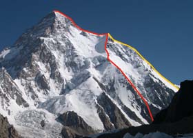
Left is K2, right is Broad Peak, and in the middle is the cloud formation.
I am not sure if this is the jet stream or not, but it is impressive...
Taken 13 July, 09:18 from Broad Peak BC."
The mets at SMHI, the Bill Nye's of weather, helped us out with this atmospheric curiosity.
These clouds are called Alto Cumulus and are not related to the Jet wind.
They form from conversion (the sun heats up the ground and the air rises)
usually the clouds get much higher than on this picture and will often develop
into precipitation.
The reason why they are so thin in this case is probably because the
rising air hit a layer of warmer air that acts like a lid (inversion). Then
the winds around the mountain (think skyscraper) catch the clouds and make
the twisting formation that you can see in the picture.
These clouds may be a prelude to the approaching storm.
Models continue to forecast an upper level trough sliding into the K2
area on this evening through Thursday. K2 should see a slow increase in winds
starting tonight with the strongest winds (20-30 m/s and gusting 30-35 m/s
at the Summit) on Friday through Sunday - possibly into Monday. Heavy showers
are also possible tomorrow through the weekend below/near 7500m. There is
a chance for upper level clouds on Thursday to mid Friday.
Image of cloud formation between K2 and Broad Peak courtesy of Jamie McGuiness.
|
|
Feature Stories |
|
Latest News |
more news |
 |
Vladimir Suviga: one in the team
Full Story
|
 |
Oscar Cadiach: following Mallory's trail
Full Story
|
 |
ExWeb tribute to the Women of K2 - Edurne's overstuffed backpack
Full Story
|
 |
K2 Plan B: The Cesen Route
Full Story
|
|
|
|
|
|
|
|
|